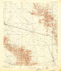
1917 Map of San Simon
USGS Topo · Published 1931About this map
Old Fort Bowie stands as a primary historical landmark in this corner of the High Desert, situated near the western edge of the Chiricahua Mountains. The landscape is dominated by the broad San Simon Valley, where the Southern Pacific railroad dictates the pattern of settlement, linking desert outposts like Bowie, Olga, and San Simon. This rail corridor supported a diverse economy of ranching and extraction, evidenced by the numerous family homesteads such as Freeman Ranch and Riggs Home Ranch, alongside industrial operations like the Willie Rose Mine and Marble Quarries.
Find a feature on this map
88 named features on this map. Tap any name to fly to it.
Don’t see what you’re looking for? This feature index may not catch every label — zoom into the map to look around manually.
Map Details
Editions of this 1917 San Simon Map
3 editions found
Other maps of this area

1916 · Pearce
USGS Topo · 1:125,000

1917 · San Simon
USGS Topo · 1:125,000

1917 · Chiricahua
USGS Topo · 1:125,000

1918 · Pratt
USGS Topo · 1:62,500

1919 · Pratt
USGS Topo · 1:62,500

1919 · Chiricahua
USGS Topo · 1:125,000

1922 · Willcox
USGS Topo · 1:125,000

1926 · Light
USGS Topo · 1:62,500

1926 · Cochise Head
USGS Topo · 1:62,500

1926 · Rodeo
USGS Topo · 1:62,500