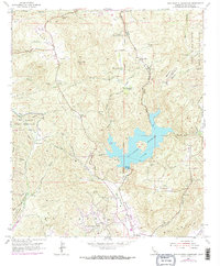
1955 Map of San Vicente Reservoir
USGS Topo · Published 1973About this map
San Vicente Reservoir dominates the center of this landscape, its shoreline defining the canyons and ridges of the San Diego backcountry during the mid-1950s. The map illustrates a transitional period for the El Cajon Grant Boundary, where traditional ranching at Goodan Ranch and Wildwood Ranch coexists with developing settlements like Eucalyptus Hills and Moreno. The rugged interior is crossed by essential fire management infrastructure, including the Foster Truck Trail and numerous firebreaks etched into the hillsides. Military presence is prominent along the western edge at the Camp Elliott Naval Reservation, while the eastern portion of the sheet borders the Barona Indian Reservation. Local topography is punctuated by family-named landmarks such as Irvings Crest and Muth Valley, alongside several active quarries near the San Vicente Creek drainage.
Find a feature on this map
37 named features on this map. Tap any name to fly to it.
Don’t see what you’re looking for? This feature index may not catch every label — zoom into the map to look around manually.
Map Details
Editions of this 1955 San Vicente Reservoir Map
4 editions found
Other maps of this area

1893 · El Cajon
USGS Topo · 1:62,500

1893 · Escondido
USGS Topo · 1:62,500

1901 · Elcajon
USGS Topo · 1:62,500

1901 · Escondido
USGS Topo · 1:62,500

1901 · San Luis Rey
USGS Topo · 1:125,000

1903 · Cuyamaca
USGS Topo · 1:125,000

1903 · La Jolla
USGS Topo · 1:62,500

1903 · Elcajon
USGS Topo · 1:62,500

1903 · Ramona
USGS Topo · 1:125,000

1904 · Southern California Sheet No. 2
USGS Topo · 1:250,000