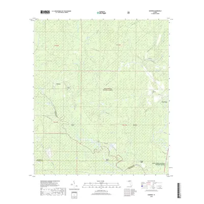
2018 Map of Sanborn
USGS Topo · Published 2018About this map
The Ochlockonee River and Sopchoppy River converge in this low-lying area of the Florida panhandle, where dense wetlands and forest lands dictate the pattern of human settlement. The landscape is defined by its complex drainage systems, including the Sufrett Creek and its various distributaries like the Sufrett Cutoff. Within these woods, the small communities of Sanborn and Sopchoppy are linked by a network of forest roads and county highways. The presence of the Sanborn McKenzie Cem and West Sopchoppy Cem provides important landmarks for genealogical research in this sparsely populated region. Historically significant sites such as Curtis Mill on the riverbank and the Schoolhouse Br suggest the early economic and social centers of these rural townships. Much of the territory is preserved within the Apalachicola National Forest and the Saint Marks National Wildlife Refuge, maintaining the character of the Florida river swamps.
Find a feature on this map
68 named features on this map. Tap any name to fly to it.
Don’t see what you’re looking for? This feature index may not catch every label — zoom into the map to look around manually.
Map Details
Editions of this 2018 Sanborn Map
This is the sole edition of this map. No revisions or reprints were ever made.
Other maps of this area

1940 · Arran
USGS Topo · 1:62,500

1943 · Arran
USGS Topo · 1:62,500

1943 · St. Teresa Beach
USGS Topo · 1:24,000

1944 · Pickett Bay
USGS Topo · 1:31,680

1945 · Thousand Yard Bay
USGS Topo · 1:31,680

1945 · Smith Creek
USGS Topo · 1:31,680

1945 · Bradwell Bay
USGS Topo · 1:31,680

1945 · Mc Intyre
USGS Topo · 1:31,680

1945 · St Teresa
USGS Topo · 1:31,680

1945 · Pickett Bay
USGS Topo · 1:31,680