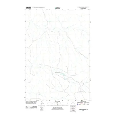
2011 Map of Sanburn Reservoir
USGS Topo · Published 2011About this map
Sanburn Reservoir and its associated Sanburn Reservoir Dam form the centerpiece of this southeastern Montana landscape. The area is defined by a dendritic network of drainages, including Horse Creek, Belle Creek, and Wright Creek, which carve through the Powder River County terrain. This topography is representative of the high plains water management systems utilized throughout the region. Notable infrastructure includes the CCC Reservoir in the north and a small network of local thoroughfares such as Belle Creek Rd and Gotfredson Rd. The distribution of these water bodies and roads reflects a landscape focused on ranching and resource management in an arid environment where water storage is vital to the local economy.
Find a feature on this map
8 named features on this map. Tap any name to fly to it.
Don’t see what you’re looking for? This feature index may not catch every label — zoom into the map to look around manually.
Map Details
Editions of this 2011 Sanburn Reservoir Map
This is the sole edition of this map. No revisions or reprints were ever made.
Other maps of this area

1954 · Ekalaka
USGS Topo · 1:250,000

1956 · Ekalaka
USGS Topo · 1:250,000

1958 · Ekalaka
USGS Topo · 1:250,000

1965 · Ekalaka
USGS Topo · 1:250,000

1970 · Pine Creek
USGS Topo · 1:24,000

1970 · Sanburn Reservoir
USGS Topo · 1:24,000
1970 · Belle Creek North
USGS Topo · 1:24,000
1970 · Belle Creek South
USGS Topo · 1:24,000

1970 · Belle Creek SW
USGS Topo · 1:24,000
1970 · Biddle
USGS Topo · 1:24,000