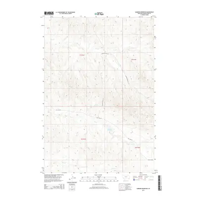
2014 Map of Sanburn Reservoir
USGS Topo · Published 2014About this map
Sanburn Reservoir and the drainage of Belle Cr anchor this high-plains landscape in Powder River County. The topography is defined by a network of seasonal watercourses, including the notable CCC Reservoir to the north and the meandering paths of Horse Cr and Wright Cr. This map documents a sparsely settled ranching environment where infrastructure is limited to primary corridors like Belle Creek Rd and Gotfredson-Wilson Rd. The surveying of township lines such as t7s r54e and t8s r53e highlights the systematic organization of this Montana territory. The presence of smaller features like Pine Cr further illustrates the complex watershed that dictates the layout of local travel and livestock management in this part of the Powder River basin.
Find a feature on this map
12 named features on this map. Tap any name to fly to it.
Don’t see what you’re looking for? This feature index may not catch every label — zoom into the map to look around manually.
Map Details
Editions of this 2014 Sanburn Reservoir Map
This is the sole edition of this map. No revisions or reprints were ever made.
Other maps of this area

1954 · Ekalaka
USGS Topo · 1:250,000

1956 · Ekalaka
USGS Topo · 1:250,000

1958 · Ekalaka
USGS Topo · 1:250,000

1965 · Ekalaka
USGS Topo · 1:250,000

1970 · Pine Creek
USGS Topo · 1:24,000

1970 · Sanburn Reservoir
USGS Topo · 1:24,000
1970 · Belle Creek North
USGS Topo · 1:24,000
1970 · Belle Creek South
USGS Topo · 1:24,000

1970 · Belle Creek SW
USGS Topo · 1:24,000
1970 · Biddle
USGS Topo · 1:24,000