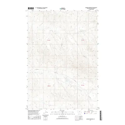
2017 Map of Sanburn Reservoir
USGS Topo · Published 2017About this map
Sanburn Reservoir anchors this high-plains landscape in southeastern Montana, where seasonal drainage patterns and ranch roads define the territory. The terrain is marked by a network of ephemeral watercourses including Rough Cr, Horse Cr, and Belle Cr, which weave between the surveyed sections of Powder River County. This 2017 survey reflects the enduring spatial organization of the Public Land Survey System, specifically detailing portions of t7s r53e and t8s r54e.
Find a feature on this map
11 named features on this map. Tap any name to fly to it.
Don’t see what you’re looking for? This feature index may not catch every label — zoom into the map to look around manually.
Map Details
Editions of this 2017 Sanburn Reservoir Map
This is the sole edition of this map. No revisions or reprints were ever made.
Other maps of this area

1954 · Ekalaka
USGS Topo · 1:250,000

1956 · Ekalaka
USGS Topo · 1:250,000

1958 · Ekalaka
USGS Topo · 1:250,000

1965 · Ekalaka
USGS Topo · 1:250,000

1970 · Pine Creek
USGS Topo · 1:24,000

1970 · Sanburn Reservoir
USGS Topo · 1:24,000
1970 · Belle Creek North
USGS Topo · 1:24,000
1970 · Belle Creek South
USGS Topo · 1:24,000

1970 · Belle Creek SW
USGS Topo · 1:24,000
1970 · Biddle
USGS Topo · 1:24,000