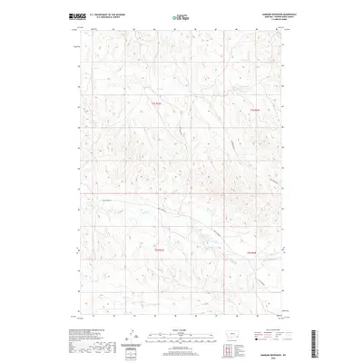
2020 Map of Sanburn Reservoir
USGS Topo · Published 2020About this map
Sanburn Reservoir anchors the southeastern landscape of this Powder River County expanse, where a network of seasonal drainages defines the local topography. The presence of the CCC Reservoir in the north serves as a reminder of early water management efforts in this semi-arid region, likely dating back to the Civilian Conservation Corps era. Transportation is limited to rugged arterials like Belle Creek Rd and Gotfredson Rd, which cut across the high plains to connect the remote cattle ranges. The map traces the winding paths of Belle Creek and Horse Creek, illustrating the delicate hydrography that sustains the local environment. This 2020 survey provides a modern baseline for these drainage patterns and range roads in a sparsely settled corner of Montana.
Find a feature on this map
13 named features on this map. Tap any name to fly to it.
Don’t see what you’re looking for? This feature index may not catch every label — zoom into the map to look around manually.
Map Details
Editions of this 2020 Sanburn Reservoir Map
This is the sole edition of this map. No revisions or reprints were ever made.
Other maps of this area

1954 · Ekalaka
USGS Topo · 1:250,000

1956 · Ekalaka
USGS Topo · 1:250,000

1958 · Ekalaka
USGS Topo · 1:250,000

1965 · Ekalaka
USGS Topo · 1:250,000

1970 · Pine Creek
USGS Topo · 1:24,000

1970 · Sanburn Reservoir
USGS Topo · 1:24,000
1970 · Belle Creek North
USGS Topo · 1:24,000
1970 · Belle Creek South
USGS Topo · 1:24,000

1970 · Belle Creek SW
USGS Topo · 1:24,000
1970 · Biddle
USGS Topo · 1:24,000