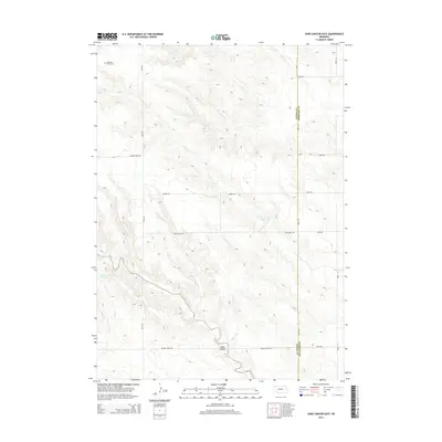
2014 Map of Sand Canyon East
USGS Topo · Published 2014About this map
The Antelope Valley Cem serves as a quiet marker of early settlement in this corner of Dawes County, located just north of the Prairie Home Rd corridor. This portion of the High Plains landscape is defined by the drainage patterns of Sand Canyon and Pepper Creek Rd, which carve through the terrain before meeting the flatter agricultural stretches to the east. Water management remains central to the region's character, evidenced by the presence of the Mirage Flats Reservoir and Houtson Reservoir. A network of section-line roads, including Long Rd, Kundra Rd, and Hughbanks Rd, reveals the enduring grid of the Nebraska panhandle’s rural ranching and farming infrastructure. The boundary between Dawes and Sheridan Counties bisects the eastern portion of the sheet, highlighting the jurisdictional divide in this sparsely populated agricultural area.
Find a feature on this map
17 named features on this map. Tap any name to fly to it.
Don’t see what you’re looking for? This feature index may not catch every label — zoom into the map to look around manually.
Map Details
Editions of this 2014 Sand Canyon East Map
This is the sole edition of this map. No revisions or reprints were ever made.
Other maps of this area

1947 · Box Butte NE
USGS Topo · 1:24,000

1947 · Box Butte NW
USGS Topo · 1:24,000

1949 · Box Butte NE
USGS Topo · 1:24,000

1949 · Box Butte NW
USGS Topo · 1:24,000

1950 · Skunk Lake
USGS Topo · 1:62,500

1955 · Alliance
USGS Topo · 1:250,000

1957 · Alliance
USGS Topo · 1:250,000

1958 · Alliance
USGS Topo · 1:250,000

1960 · Hay Springs SW
USGS Topo · 1:24,000

1966 · Chadron 3 SE
USGS Topo · 1:24,000