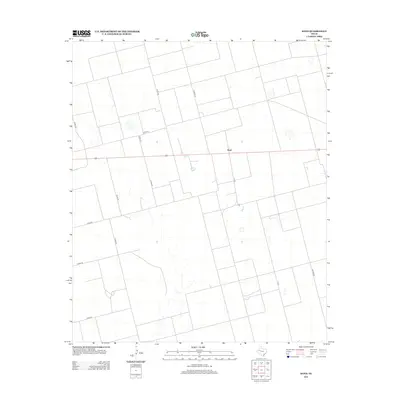
2012 Map of Sand
USGS Topo · Published 2012About this map
Sand occupies a central position in this corner of Dawson County, characterized by the expansive, grid-like geometry of West Texas ranch and farm land. The landscape is defined by a systematic network of county roads, including the prominent north-south transit of Co Road Cc and its variation C R Cc, which provide the primary framework for local travel through this high plains region. Sparse settlement patterns are evident, with the small community of Sand appearing as a focused point of activity amidst larger parcels of land. Other arterial routes like Co Road Bb and Co Rd-145 delineate the boundaries of this agricultural territory. The map illustrates the specialized infrastructure of the Llano Estacado, where wide-open spaces are managed through a precise grid of secondary roads such as Co Rd-451 and Co Rd-100.
Find a feature on this map
13 named features on this map. Tap any name to fly to it.
Don’t see what you’re looking for? This feature index may not catch every label — zoom into the map to look around manually.
Map Details
Editions of this 2012 Sand Map
This is the sole edition of this map. No revisions or reprints were ever made.
Other maps of this area

1954 · Hobbs
USGS Topo · 1:250,000

1958 · Hobbs
USGS Topo · 1:250,000

1969 · Welch SW
USGS Topo · 1:24,000

1969 · Punkin Center
USGS Topo · 1:24,000

1970 · Patricia SW
USGS Topo · 1:24,000

1970 · Patricia
USGS Topo · 1:24,000

1970 · McKenzie Lake SE
USGS Topo · 1:24,000

1970 · Sand
USGS Topo · 1:24,000

1970 · McKenzie Lake
USGS Topo · 1:24,000
1970 · Cedar Point
USGS Topo · 1:24,000