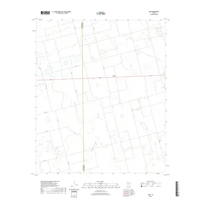
2019 Map of Sand
USGS Topo · Published 2019About this map
Sand occupies a central position within this West Texas landscape, situated along the county line where Gaines Co meets Dawson Co. The terrain is defined by the ephemeral path of McKenzie Draw, which winds through a geometric grid of local transit routes. This network of thoroughfares, including Co Rd CC and Co Rd 100, reflects the systematic land divisions characteristic of the High Plains agricultural and ranching economy. The scarcity of permanent surface water is underscored by the intermittent nature of the draw, highlighting the importance of groundwater and human-engineered infrastructure for settlement in this part of the state. Small depressions and localized topography interrupt the broad plains, providing subtle variations in an otherwise expansive and open landscape.
Find a feature on this map
14 named features on this map. Tap any name to fly to it.
Don’t see what you’re looking for? This feature index may not catch every label — zoom into the map to look around manually.
Map Details
Editions of this 2019 Sand Map
This is the sole edition of this map. No revisions or reprints were ever made.
Other maps of this area

1954 · Hobbs
USGS Topo · 1:250,000

1958 · Hobbs
USGS Topo · 1:250,000

1969 · Welch SW
USGS Topo · 1:24,000

1969 · Punkin Center
USGS Topo · 1:24,000

1970 · Patricia SW
USGS Topo · 1:24,000

1970 · Patricia
USGS Topo · 1:24,000

1970 · McKenzie Lake SE
USGS Topo · 1:24,000

1970 · Sand
USGS Topo · 1:24,000

1970 · McKenzie Lake
USGS Topo · 1:24,000
1970 · Cedar Point
USGS Topo · 1:24,000