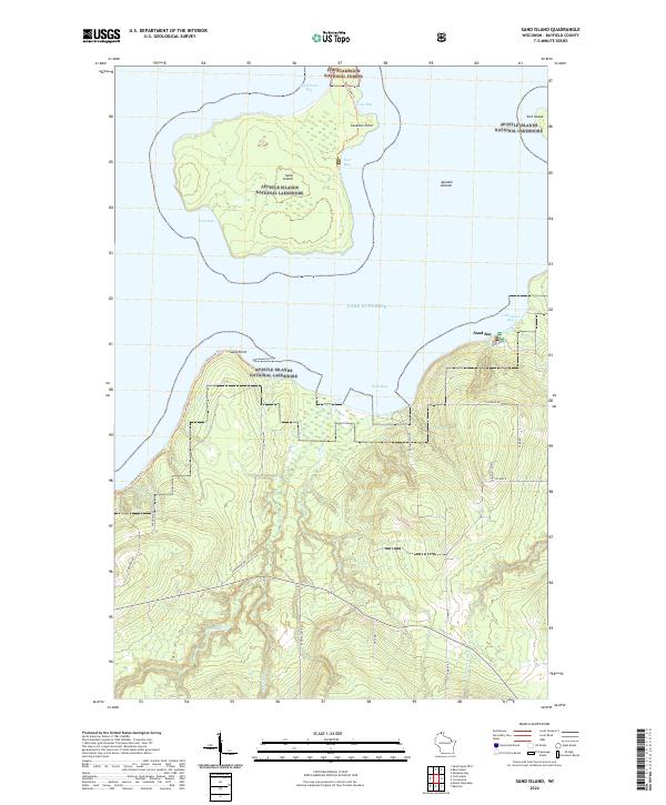
2022 Map of Sand Island
USGS Topo · Published 2022About this map
Sand Island and its surrounding waters define this coastal stretch of the Apostle Islands National Lakeshore on the southern rim of Lake Superior. The landscape is dominated by the interplay of dense woodland and the rocky shoreline, with Sand Island Trl and Sea Caves Trl providing access to points like Swallow Point and the sheltered Justice Bay. On the mainland, the shoreline curves from the rocky protrusions at Sand Point toward the recreational hub at Little Sand Bay. The interior is defined by the drainage basins of the Sand River and Raspberry River, which flow through the northern reaches of the Chequamegon National Forest. A network of local roads including Co Hwy K and Engholm Rd connect the scattered homesteads and timberlands of the Bayfield Peninsula, where the rugged topography transitions into the cold depths of the lake.
Find a feature on this map
34 named features on this map. Tap any name to fly to it.
Don’t see what you’re looking for? This feature index may not catch every label — zoom into the map to look around manually.
Map Details
Editions of this 2022 Sand Island Map
This is the sole edition of this map. No revisions or reprints were ever made.
Other maps of this area

1941 · Bayfield
USGS Topo · 1:48,000

1944 · Cornucopia
USGS Topo · 1:48,000

1946 · Cornucopia
USGS Topo · 1:48,000

1946 · Bayfield
USGS Topo · 1:48,000

1953 · Ashland
USGS Topo · 1:250,000

1954 · Two Harbors
USGS Topo · 1:250,000

1957 · Two Harbors
USGS Topo · 1:250,000

1958 · Ashland
USGS Topo · 1:250,000

1958 · Two Harbors
USGS Topo · 1:250,000
1963 · Bear Island
USGS Topo · 1:24,000