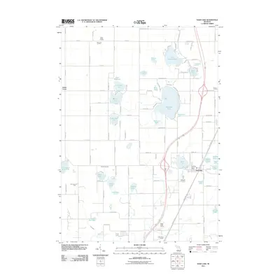
2011 Map of Sand Lake
USGS Topo · Published 2011About this map
Whitefish Lake and Little Whitefish Lake dominate this landscape, reflecting the lake-dotted geography of Kent and Montcalm Counties as it appeared in the early 21st century. The village of Sand Lake serves as a local hub, featuring the Sand Lake Post Office and Sand Lake Cemetery near the intersections of local routes like W Lake St and E Lake St. The surrounding countryside is interspersed with historical burial grounds including Pierson Cemetery and North Ensley Cemetery, alongside smaller settlements like Ensley Center. To the south, aviation infrastructure is noted at North Cedar Airport and Wilds Field Airport, while the Fisk Lookout Tower stands as a landmark near Cook and White Lake. The intricate water network is further defined by Duke Creek and Frost Creek, which connect numerous smaller bodies of water such as Baptist Lake, Middle Lake, and No-Ko-Mos Lake.
Find a feature on this map
67 named features on this map. Tap any name to fly to it.
Don’t see what you’re looking for? This feature index may not catch every label — zoom into the map to look around manually.
Map Details
Editions of this 2011 Sand Lake Map
This is the sole edition of this map. No revisions or reprints were ever made.
Other maps of this area

1918 · Cedar Springs
USGS Topo · 1:62,500

1943 · Cedar Springs
USGS Topo · 1:62,500

1954 · Midland
USGS Topo · 1:250,000

1958 · Midland
USGS Topo · 1:250,000

1958 · Sand Lake
USGS Topo · 1:62,500

1959 · Midland
USGS Topo · 1:250,000

1959 · Howard City
USGS Topo · 1:62,500

1966 · Midland
USGS Topo · 1:250,000

1967 · Sparta
USGS Topo · 1:24,000

1967 · Cedar Springs
USGS Topo · 1:24,000