
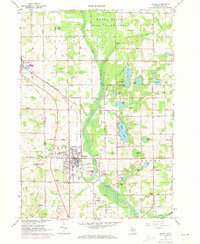
1967 Map of Sparta
USGS Topo · Published 1969About this map
The Rogue River winds through the northern portion of this West Michigan landscape, anchoring a diverse terrain of wetlands, small lakes, and growing rural communities. In Sparta, the grid of streets and the Sparta Airport reflect a mid-century period of local development, while the Chesapeake and Ohio Railroad provides a vital transportation link cutting diagonally across the quadrangle. The map is a rich resource for family historians, documenting numerous rural education sites such as Christian Hill Sch, Myers Sch, and Morning Star Sch, alongside community landmarks like Idlewild Cem and Fairplains Cem. To the north, the State Game Area preserves a pocket of undeveloped land, contrasting with the active Gravel Pits and family farms that defined the local economy during the late 1960s.
Find a feature on this map
67 named features on this map. Tap any name to fly to it.
Don’t see what you’re looking for? This feature index may not catch every label — zoom into the map to look around manually.
Map Details
Editions of this 1967 Sparta Map
2 editions found
Other maps of this area

1918 · Cedar Springs
USGS Topo · 1:62,500

1943 · Cedar Springs
USGS Topo · 1:62,500

1945 · Ravenna
USGS Topo · 1:62,500

1954 · Midland
USGS Topo · 1:250,000

1958 · Midland
USGS Topo · 1:250,000

1958 · Sand Lake
USGS Topo · 1:62,500

1958 · Fremont
USGS Topo · 1:62,500

1959 · Midland
USGS Topo · 1:250,000

1966 · Midland
USGS Topo · 1:250,000

1967 · Cedar Springs
USGS Topo · 1:24,000