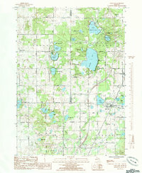
1985 Map of Sand Lake
USGS Topo · Published 1985About this map
Glacial lakes and wetlands define the borderlands of Kent, Newaygo, and Montcalm counties in the mid-1980s. The village of Sand Lake serves as a local hub, situated near a complex system of water bodies including Breford Lake and Gidding Lake. This period shows a landscape transitioning between traditional rural crossroads like Eisley Center and expanding recreational or residential areas, evidenced by the numerous cemeteries and parks that dot the townships.
Find a feature on this map
62 named features on this map. Tap any name to fly to it.
Don’t see what you’re looking for? This feature index may not catch every label — zoom into the map to look around manually.
Map Details
Editions of this 1985 Sand Lake Map
This is the sole edition of this map. No revisions or reprints were ever made.
Other maps of this area

1918 · Cedar Springs
USGS Topo · 1:62,500

1943 · Cedar Springs
USGS Topo · 1:62,500

1954 · Midland
USGS Topo · 1:250,000

1958 · Midland
USGS Topo · 1:250,000

1958 · Sand Lake
USGS Topo · 1:62,500

1959 · Midland
USGS Topo · 1:250,000

1959 · Howard City
USGS Topo · 1:62,500

1966 · Midland
USGS Topo · 1:250,000

1967 · Sparta
USGS Topo · 1:24,000

1967 · Cedar Springs
USGS Topo · 1:24,000