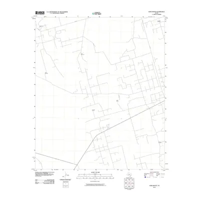
2010 Map of Sand Ranch
USGS Topo · Published 2010About this map
Figure Three Ranch and the namesake Sand Ranch anchor this West Texas landscape in Andrews County, where cattle ranching and energy extraction intersect. The terrain is defined by a network of ranch roads and specialized water sources, including the South Windmill and Overly Windmill, which are essential for maintaining livestock in this semi-arid environment. Beyond the homesteads, the industrial footprint of the Permian Basin is evident through the sprawling operations of the Three Bar Oil Field and the South Nix Oil Field in the northeast. The presence of the Burma Windmill near the southern boundary suggests the continued reliance on traditional wind-powered infrastructure even as the region developed modern thoroughfares like S FM 181 and SW 900.
Find a feature on this map
11 named features on this map. Tap any name to fly to it.
Don’t see what you’re looking for? This feature index may not catch every label — zoom into the map to look around manually.
Map Details
Editions of this 2010 Sand Ranch Map
This is the sole edition of this map. No revisions or reprints were ever made.
Other maps of this area

1954 · Hobbs
USGS Topo · 1:250,000

1958 · Hobbs
USGS Topo · 1:250,000

1968 · Coyote Corner
USGS Topo · 1:24,000

1968 · North Cowden NW
USGS Topo · 1:24,000

1971 · Figure Seven Ranch
USGS Topo · 1:24,000

1971 · Whalen Lake
USGS Topo · 1:24,000

1971 · Bedford Ranch
USGS Topo · 1:24,000

1971 · Frankel City SW
USGS Topo · 1:24,000

1971 · Sand Ranch
USGS Topo · 1:24,000
1971 · Y T Ranch
USGS Topo · 1:24,000