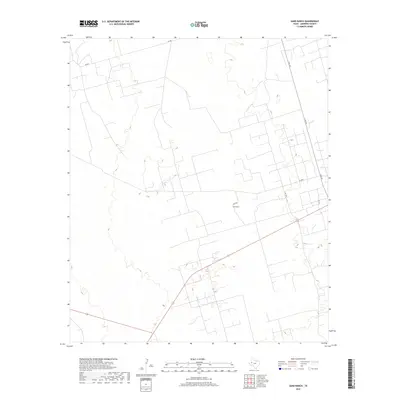
2019 Map of Sand Ranch
USGS Topo · Published 2019About this map
Sand Ranch anchors this high plains landscape in Andrews County, where a complex network of local roads and cattle tracks defines the modern ranching economy. The topography is subtle, characterized by the gentle depressions and intermittent drainages typical of the Permian Basin. Arcing through the eastern portion of the map, S Fm 181 serves as the primary artery connecting these remote ranching operations to the wider region. The grid of service roads, including Sw 7401 and Sw 900, reveals a landscape organized for utility and large-scale land management. This 2019 survey, produced by the U.S. Geological Survey, uses imagery from the National Agriculture Imagery Program to document the contemporary footprint of West Texas ranch life.
Find a feature on this map
7 named features on this map. Tap any name to fly to it.
Don’t see what you’re looking for? This feature index may not catch every label — zoom into the map to look around manually.
Map Details
Editions of this 2019 Sand Ranch Map
This is the sole edition of this map. No revisions or reprints were ever made.
Other maps of this area

1954 · Hobbs
USGS Topo · 1:250,000

1958 · Hobbs
USGS Topo · 1:250,000

1968 · Coyote Corner
USGS Topo · 1:24,000

1968 · North Cowden NW
USGS Topo · 1:24,000

1971 · Figure Seven Ranch
USGS Topo · 1:24,000

1971 · Whalen Lake
USGS Topo · 1:24,000

1971 · Bedford Ranch
USGS Topo · 1:24,000

1971 · Frankel City SW
USGS Topo · 1:24,000

1971 · Sand Ranch
USGS Topo · 1:24,000
1971 · Y T Ranch
USGS Topo · 1:24,000