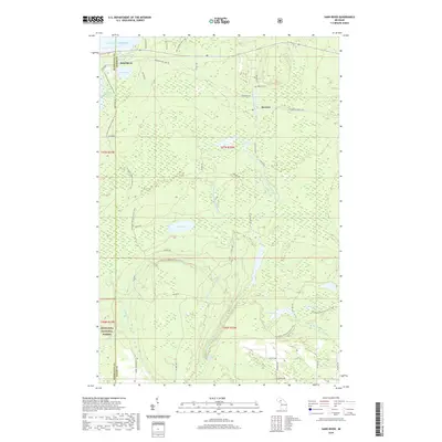
2019 Map of Sand River
USGS Topo · Published 2019About this map
The southern shoreline of Lake Superior dominates the northern edge of this Upper Peninsula landscape, where the settlements of Sand River and Deerton are connected by a network of rural roads and the historic path of Railroad Ln. This area is defined by its complex hydrology, featuring the Laughing Whitefish River and its various branches, as well as the significant Laughing Whitefish Falls located within the southern reaches of the quadrangle. A large portion of the territory is protected within the Hiawatha National Forest, illustrating the region's managed wilderness character. Local history is anchored by the Deerton Cem and several family-named landmarks like the James D'Jeske Flooding. The N Country National Scenic Trail winds through the diverse terrain, passing numerous inland water bodies including Howe Lake and Silver Lake.
Find a feature on this map
41 named features on this map. Tap any name to fly to it.
Don’t see what you’re looking for? This feature index may not catch every label — zoom into the map to look around manually.
Map Details
Editions of this 2019 Sand River Map
This is the sole edition of this map. No revisions or reprints were ever made.
Other maps of this area

1932 · Skandia SW
USGS Topo · 1:31,680

1932 · Skandia SE
USGS Topo · 1:31,680

1932 · Skandia NE
USGS Topo · 1:31,680

1950 · Skandia NW
USGS Topo · 1:31,680

1958 · Au Train
USGS Topo · 1:62,500

1958 · Laughing Fish Point
USGS Topo · 1:62,500

1958 · Skandia
USGS Topo · 1:62,500

1958 · Marquette
USGS Topo · 1:250,000

1960 · Marquette
USGS Topo · 1:250,000

1961 · Marquette
USGS Topo · 1:250,000
Featured Places
- Skandia Township, MI
- Rock River Township, MI
- Sand River, Onota Township
- Onota Township, MI
- Chocolay Township, MI