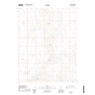
2018 Map of Sand Spring
USGS Topo · Published 2018About this map
Sand Spring serves as a focal point in this high-desert landscape within the Pancake Range, where water sources define the geography. These vital hydrologic features, including Martilletti Spring, Portuguese Spring, and Coyote Spring, are scattered across the terrain, indicating the historical importance of reliable water in the Great Basin. To the south, the massive Portuguese Mtn rises above the drainage of Ike Spring Wash, while the surrounding basins of Big Sand Springs Valley and Duckwater Valley show the characteristic open-range topography of Nye County. The lack of modern development emphasizes a preserved wilderness state, where these named springs remain the primary landmarks for navigation and land use in a region dominated by sagebrush and mountain ridges.
Find a feature on this map
14 named features on this map. Tap any name to fly to it.
Don’t see what you’re looking for? This feature index may not catch every label — zoom into the map to look around manually.
Map Details
Editions of this 2018 Sand Spring Map
This is the sole edition of this map. No revisions or reprints were ever made.
Other maps of this area

1956 · Lund
USGS Topo · 1:250,000

1960 · Lund
USGS Topo · 1:250,000

1964 · Blue Eagle Springs
USGS Topo · 1:62,500

1964 · Duckwater
USGS Topo · 1:62,500

1968 · Portuguese Mtn
USGS Topo · 1:62,500

1968 · Brown Summit
USGS Topo · 1:24,000
1968 · Brown Summit NW
USGS Topo · 1:24,000
1968 · Brown Summit SW
USGS Topo · 1:24,000
1968 · Sand Spring
USGS Topo · 1:24,000

1968 · Portuguese Mtn
USGS Topo · 1:24,000