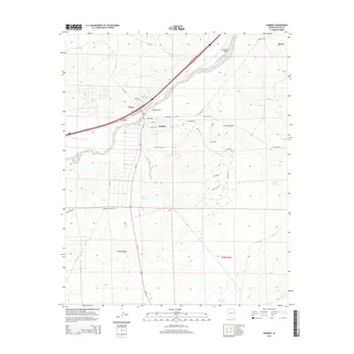
2014 Map of Sanders
USGS Topo · Published 2014About this map
Sanders and Houck anchor this high-desert landscape, where the Puerco River and its seasonal tributaries carve distinct pathways across the terrain. The presence of Emigrant Springs and various water storage features like Middle Tank and Bens Dam Tank points to the vital importance of water resources in this arid region of the Southwest. Modern transit corridors follow historical routes, with major highways and local tracks like Clay Mine Rd and Navajo Blvd connecting the scattered settlements. The map documents a sparsely populated but geographically complex area where residential clusters like Chetco exist alongside named topographic features such as Tolapai Draw and the extensive Burntwater Wash. This detailed view of the landscape reveals the placement of individual structures and rural subdivisions, providing a clear record of land use and human settlement patterns along the river valley and its surrounding slopes.
Find a feature on this map
38 named features on this map. Tap any name to fly to it.
Don’t see what you’re looking for? This feature index may not catch every label — zoom into the map to look around manually.
Map Details
Editions of this 2014 Sanders Map
This is the sole edition of this map. No revisions or reprints were ever made.
Other maps of this area

1886 · Fort Defiance
USGS Topo · 1:250,000

1892 · Fort Defiance
USGS Topo · 1:250,000

1954 · Gallup
USGS Topo · 1:250,000

1958 · Gallup
USGS Topo · 1:250,000

1959 · Gallup
USGS Topo · 1:250,000

1962 · Gallup
USGS Topo · 1:250,000

1967 · Gallup
USGS Topo · 1:250,000

1971 · Burntwater Wash
USGS Topo · 1:24,000
1971 · Sanders
USGS Topo · 1:24,000
1971 · Chambers
USGS Topo · 1:24,000