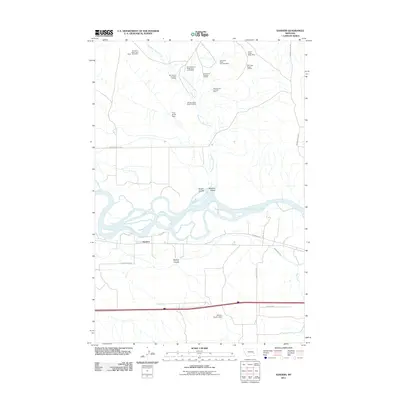
2011 Map of Sanders
USGS Topo · Published 2011About this map
Sanders and the surrounding Treasure County ranch lands are defined by the wide, braided path of the Yellowstone River, which dominates the central portion of the landscape. To the north, a significant concentration of coal mining activity is visible, characterized by several sites with distinctive names like the SW Starved to Death-15 Mine and the SW Cedar Ridge Complex Mine. The infrastructure supporting these operations includes specialized routes such as the Starved To Death Haul Road - Nine Mine, which snakes through the drainage of Starved to Death Creek. South of the river, the irrigation network of the Yellowstone Canal supports local agricultural efforts near Deveny Coulee, where the Deveny Coulee Dam manages water resources. This map captures a rural landscape where industrial mineral extraction and river-bottom farming exist in close proximity.
Find a feature on this map
26 named features on this map. Tap any name to fly to it.
Don’t see what you’re looking for? This feature index may not catch every label — zoom into the map to look around manually.
Map Details
Editions of this 2011 Sanders Map
This is the sole edition of this map. No revisions or reprints were ever made.
Other maps of this area

1954 · Forsyth
USGS Topo · 1:250,000

1957 · Forsyth
USGS Topo · 1:250,000

1958 · Forsyth
USGS Topo · 1:250,000

1960 · Hysham
USGS Topo · 1:24,000

1960 · Vananda
USGS Topo · 1:24,000

1960 · Ahles
USGS Topo · 1:24,000

1960 · Sanders
USGS Topo · 1:24,000

1968 · Donleys Reservoir
USGS Topo · 1:24,000

1968 · Finch
USGS Topo · 1:24,000
1971 · Griffin Coulee NW
USGS Topo · 1:24,000