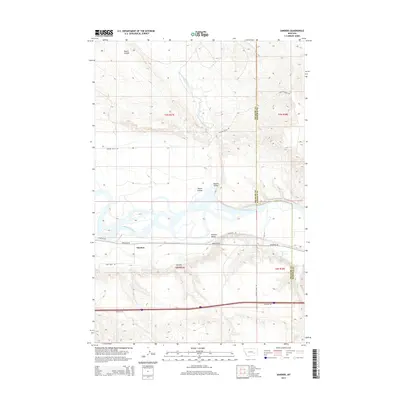
2014 Map of Sanders
USGS Topo · Published 2014About this map
The Yellowstone River anchors this central Montana landscape, cutting a wide corridor between the higher plateaus of Treasure and Rosebud counties. The settlement of Sanders occupies the southern bank, situated along the transport corridor defined by the Frontage Rd and railroad lines. This map illustrates the vital role of water management in the region’s agricultural economy, specifically through the Yellowstone Canal, which follows the southern river bench. To the north, the terrain is deeply dissected by drainages such as Starved to Death Cr and Roach Coulee, highlighting the shift from the fertile bottomlands of Howard Valley and Mission Valley to the more arid, cattle-grazing uplands. Local family histories are reflected in named tracks like Haines Ranch Rd and Sarpy Farm Rd.
Find a feature on this map
19 named features on this map. Tap any name to fly to it.
Don’t see what you’re looking for? This feature index may not catch every label — zoom into the map to look around manually.
Map Details
Editions of this 2014 Sanders Map
This is the sole edition of this map. No revisions or reprints were ever made.
Other maps of this area

1954 · Forsyth
USGS Topo · 1:250,000

1957 · Forsyth
USGS Topo · 1:250,000

1958 · Forsyth
USGS Topo · 1:250,000

1960 · Hysham
USGS Topo · 1:24,000

1960 · Vananda
USGS Topo · 1:24,000

1960 · Ahles
USGS Topo · 1:24,000

1960 · Sanders
USGS Topo · 1:24,000

1968 · Donleys Reservoir
USGS Topo · 1:24,000

1968 · Finch
USGS Topo · 1:24,000
1971 · Griffin Coulee NW
USGS Topo · 1:24,000