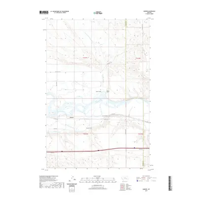
2020 Map of Sanders
USGS Topo · Published 2020About this map
The Sanders settlement sits at the heart of this Treasure County landscape, where the wide braided channels of the Yellowstone River dictate the local geography. The map reveals an intricate irrigation network essential to this semi-arid region, featuring the Yellowstone Canal and the Hysham Canal which parallel the river's southern bank. To the north, the terrain transitions into a series of named drainages and topographic depressions, including the evocative Starved to Death Cr and the broad expanse of Mission Valley. These landforms, along with Roach Coulee and Deveny Coulee, illustrate the erosion patterns characteristic of the Yellowstone valley's northern rim. Transportation corridors like Old Hwy 10 and Mission Valley Rd follow the natural contours of the river valley, marking the historical and modern transit routes through this section of eastern Montana.
Find a feature on this map
24 named features on this map. Tap any name to fly to it.
Don’t see what you’re looking for? This feature index may not catch every label — zoom into the map to look around manually.
Map Details
Editions of this 2020 Sanders Map
This is the sole edition of this map. No revisions or reprints were ever made.
Other maps of this area

1954 · Forsyth
USGS Topo · 1:250,000

1957 · Forsyth
USGS Topo · 1:250,000

1958 · Forsyth
USGS Topo · 1:250,000

1960 · Hysham
USGS Topo · 1:24,000

1960 · Vananda
USGS Topo · 1:24,000

1960 · Ahles
USGS Topo · 1:24,000

1960 · Sanders
USGS Topo · 1:24,000

1968 · Donleys Reservoir
USGS Topo · 1:24,000

1968 · Finch
USGS Topo · 1:24,000
1971 · Griffin Coulee NW
USGS Topo · 1:24,000