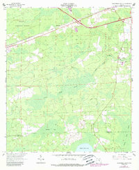
1963 Map of Sanderson South
USGS Topo · Published 1988About this map
The Osceola National Forest dominates the northwest corner of this Baker County landscape, where the Seaboard Coast Line railroad runs parallel to Interstate 10. The settlement of Sanderson is positioned along the northern edge, serving as a focal point near Manns Spur and the State Nursery. This era shows a community reliant on both the rail corridor and the surrounding timberlands, with a network of Fire Trails and Jeep Trails cutting through the dense southern wetlands.
Find a feature on this map
34 named features on this map. Tap any name to fly to it.
Don’t see what you’re looking for? This feature index may not catch every label — zoom into the map to look around manually.
Map Details
Editions of this 1963 Sanderson South Map
2 editions found
Other maps of this area

1917 · Macclenny
USGS Topo · 1:62,500

1918 · Lawtey
USGS Topo · 1:62,500

1918 · Macclenny
USGS Topo · 1:62,500

1954 · Valdosta
USGS Topo · 1:250,000

1958 · Valdosta
USGS Topo · 1:250,000

1959 · Valdosta
USGS Topo · 1:250,000

1963 · Olustee
USGS Topo · 1:24,000

1963 · Sanderson South
USGS Topo · 1:24,000

1966 · Lake Butler
USGS Topo · 1:24,000
1966 · Lulu
USGS Topo · 1:24,000