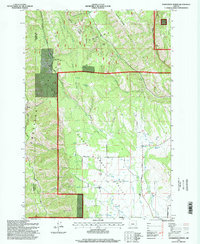
1995 Map of Sanderson Spring
USGS Topo · Published 1998About this map
The Umatilla National Forest dominates the northern reaches of this Union County landscape, where the rugged descent from Huckleberry Mountain and Middle Ridge gives way to the open agricultural expanse of the Grande Ronde Valley. Evidence of the region’s long-standing grazing and timber traditions is visible in isolated outposts like Finley Creek Cow Camp, Stanley Cabin, and Craigs Cabin, which are scattered among the canyons and ridges.
Find a feature on this map
42 named features on this map. Tap any name to fly to it.
Don’t see what you’re looking for? This feature index may not catch every label — zoom into the map to look around manually.
Map Details
Editions of this 1995 Sanderson Spring Map
This is the sole edition of this map. No revisions or reprints were ever made.
Other maps of this area

1906 · Telocaset
USGS Topo · 1:125,000

1953 · Pendleton
USGS Topo · 1:250,000

1955 · Grangeville
USGS Topo · 1:250,000

1956 · Pendleton
USGS Topo · 1:250,000

1959 · Grangeville
USGS Topo · 1:250,000

1963 · Andies Prairie
USGS Topo · 1:24,000

1963 · Sanderson Spring
USGS Topo · 1:24,000

1963 · Bingham Springs
USGS Topo · 1:24,000

1963 · Summerville
USGS Topo · 1:24,000

1964 · Partridge Creek
USGS Topo · 1:24,000