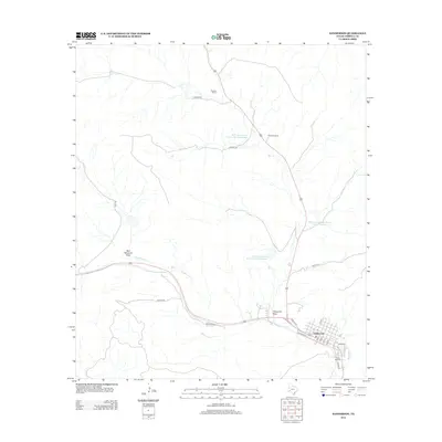
2012 Map of Sanderson
USGS Topo · Published 2012About this map
Sanderson serves as the primary hub in this arid West Texas landscape, where the town's grid meets the wandering path of Sanderson Cr. The town's layout is defined by streets like Avenue E and Legion St, with the Santa Rita Cem situated on the southern edge. This 2012 survey illustrates a landscape deeply tied to ranching and water management, featuring several large private holdings such as Downie Ranch, Goldwire Ranch, and Deaton Ranch. The infrastructure of the high desert is evident in the network of rural roads like Deaton RD and the series of water retention projects managed by the Soil Conservation Service, including Soil Conservation Service Site 8 Reservoir and Soil Conservation Service Site 9 Reservoir. Natural drainages like Red Windmill Draw and Threemile Draw cut through the terrain, highlighting the geological features that dictate the placement of ranch houses and transit routes.
Find a feature on this map
19 named features on this map. Tap any name to fly to it.
Don’t see what you’re looking for? This feature index may not catch every label — zoom into the map to look around manually.
Map Details
Editions of this 2012 Sanderson Map
This is the sole edition of this map. No revisions or reprints were ever made.
Other maps of this area

1920 · Longfellow
USGS Topo · 1:125,000

1928 · Sanderson
USGS Topo · 1:125,000

1954 · Fort Stockton
USGS Topo · 1:250,000

1958 · Fort Stockton
USGS Topo · 1:250,000

1968 · Big Brindle Canyon
USGS Topo · 1:24,000

1968 · Toms Canyon
USGS Topo · 1:24,000

1968 · Ninemile Ranch
USGS Topo · 1:24,000

1969 · Sanderson SE
USGS Topo · 1:24,000

1969 · Sanderson
USGS Topo · 1:24,000

1969 · Big Canyon Ranch
USGS Topo · 1:24,000