
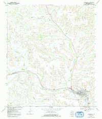
1969 Map of Sanderson
USGS Topo · Published 1972About this map
The town of Sanderson serves as a vital railroad and ranching hub in this 1960s survey of Terrell County. The Southern Pacific railroad cuts directly through the center of the settlement, paralleling the course of Sanderson Canyon Creek. This industrial corridor is defined by supporting infrastructure including a Gaging Sta, an Athletic Field, and a local Trailer Park. Nearby, the Santa Rita Cem and Cedar Grove Cem provide essential touchpoints for genealogists researching family histories in the West Texas landscape.
Find a feature on this map
24 named features on this map. Tap any name to fly to it.
Don’t see what you’re looking for? This feature index may not catch every label — zoom into the map to look around manually.
Map Details
Editions of this 1969 Sanderson Map
2 editions found
Other maps of this area

1920 · Longfellow
USGS Topo · 1:125,000

1928 · Sanderson
USGS Topo · 1:125,000

1954 · Fort Stockton
USGS Topo · 1:250,000

1958 · Fort Stockton
USGS Topo · 1:250,000

1968 · Big Brindle Canyon
USGS Topo · 1:24,000

1968 · Toms Canyon
USGS Topo · 1:24,000

1968 · Ninemile Ranch
USGS Topo · 1:24,000

1969 · Sanderson SE
USGS Topo · 1:24,000

1969 · Big Canyon Ranch
USGS Topo · 1:24,000
1969 · Big Canyon Ranch SW
USGS Topo · 1:24,000