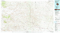
1985 Map of Sanderson
USGS Topo · Published 1993About this map
The Southern Pacific Railroad and US Highway 90 form the primary lifeblood of this Trans-Pecos landscape, following the natural corridors carved by Sanderson Creek and Dry Creek. Centered on the town of Sanderson, the seat of Terrell County, the map captures a period where ranching outposts and rail stops like Dryden, Tesnus, and Rosenfeld defined the sparse human geography of the Chihuahuan Desert. The terrain is a complex system of drainage and elevation, from the Glass Mountains and W B Flats in the northwest to the deep incisions of Big Canyon and Downie Draw.
Find a feature on this map
39 named features on this map. Tap any name to fly to it.
Don’t see what you’re looking for? This feature index may not catch every label — zoom into the map to look around manually.
Map Details
Editions of this 1985 Sanderson Map
2 editions found
Other maps of this area

1917 · Hood Spring
USGS Topo · 1:62,500

1918 · Bone Spring
USGS Topo · 1:125,000

1918 · Hood Spring
USGS Topo · 1:62,500

1918 · Dryden Crossing
USGS Topo · 1:62,500

1918 · Dove Mountain
USGS Topo · 1:62,500

1918 · Bullis Gap
USGS Topo · 1:62,500

1918 · Indian Wells
USGS Topo · 1:62,500

1920 · Longfellow
USGS Topo · 1:125,000

1920 · Marathon
USGS Topo · 1:62,500

1921 · Marathon
USGS Topo · 1:62,500