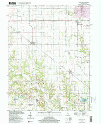
1998 Map of Sandford
USGS Topo · Published 2002About this map
Vermilion and Sandford anchor this landscape along the Illinois-Indiana border, where the townships of Stratton, Clinton, and Fayette meet. The terrain is defined by a series of waterways, including the winding course of Sugar Creek and its tributaries like Indian Creek and McCalls Branch. The 1998 photoinspection reveals a rural infrastructure marked by numerous Gas Storage Wells and a Pumping Station, indicating the industrial significance of the subsurface resources in Elbridge and surrounding areas. For those tracing local heritage, the map identifies several country houses of worship such as Little Grove Ch and Pisgah Ch, alongside scattered family and community burial grounds like Blackburn Cem, Pryor Cem, and Stults Cem. The southern portion of the map includes the Green Valley State Fishing Area, showing the repurposed landscape at the Green Valley Mine Pond.
Find a feature on this map
50 named features on this map. Tap any name to fly to it.
Don’t see what you’re looking for? This feature index may not catch every label — zoom into the map to look around manually.
Map Details
Editions of this 1998 Sandford Map
This is the sole edition of this map. No revisions or reprints were ever made.
Other maps of this area

1932 · Marshall
USGS Topo · 1:62,500

1937 · Marshall
USGS Topo · 1:62,500

1941 · Terre Haute
USGS Topo · 1:24,000

1942 · Dennison
USGS Topo · 1:24,000

1947 · Paris
USGS Topo · 1:62,500

1948 · Terre Haute
USGS Topo · 1:24,000

1949 · Paris
USGS Topo · 1:62,500

1950 · New Goshen
USGS Topo · 1:24,000

1950 · Sandford
USGS Topo · 1:24,000

1951 · Clinton
USGS Topo · 1:24,000