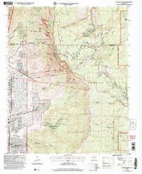
2006 Map of Sandia Crest
USGS Topo · Published 2007About this map
Sandia Mountain dominates this 2006 revision, where the urban edge of Albuquerque meets the steep eastern rises of the Cibola National Forest. The map documents a complex landscape of land grants and conservation areas, including the Sandia Pueblo Grant and the Elena Gallegos Grant. Notable recreational and cultural landmarks are scattered across the peaks, from the Sandia Peak Aerial Tramway and Sandia Peak Ski Area to historic structures like Juan Tabo Cabin and Kiwanis Cabin. The survey provides a clear view of the transition between developed parklands like Albert G Simms City Park and the protected Sandia Mountain Wilderness. Dozens of vital water sources are named throughout the canyons, such as Embudo Spring and Osha Spring, which have historically supported both the high-altitude ranching at Ellis Ranch and the communities along the foothills.
Find a feature on this map
61 named features on this map. Tap any name to fly to it.
Don’t see what you’re looking for? This feature index may not catch every label — zoom into the map to look around manually.
Map Details
Editions of this 2006 Sandia Crest Map
This is the sole edition of this map. No revisions or reprints were ever made.
Other maps of this area

1888 · Bernalillo
USGS Topo · 1:125,000

1889 · Albuquerque
USGS Topo · 1:125,000

1892 · San Pedro
USGS Topo · 1:125,000

1893 · Albuquerque
USGS Topo · 1:125,000

1934 · Alameda
USGS Topo · 1:24,000

1934 · East Albuquerque
USGS Topo · 1:24,000

1938 · Albuquerque
USGS Topo · 1:62,500

1954 · Sandia Crest
USGS Topo · 1:24,000

1954 · Alameda
USGS Topo · 1:24,000

1954 · Placitas
USGS Topo · 1:24,000
Featured Places
- Albuquerque, NM
- Cedar Crest, NM
- Evergreen Hills Subdivision, NM
- Cooper LS Ranch, NM
- Glenwood Hills, Albuquerque