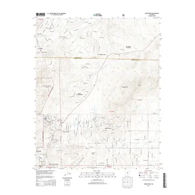
2013 Map of Sandia Park
USGS Topo · Published 2013About this map
Cibola National Forest defines the western edge of this New Mexico landscape, where the high terrain of the Sandia Mountains gives way to numerous canyons and residential enclaves. Modern developments like the Paako Communities and Sandia Knolls are shown alongside established settlements including San Antonio and Sandia Park. The geography is deeply carved by drainage systems such as Arroyo Armijo, Frost Arroyo, and Arroyo Seco, which define the local topography.
Find a feature on this map
30 named features on this map. Tap any name to fly to it.
Don’t see what you’re looking for? This feature index may not catch every label — zoom into the map to look around manually.
Map Details
Editions of this 2013 Sandia Park Map
This is the sole edition of this map. No revisions or reprints were ever made.
Other maps of this area

1892 · San Pedro
USGS Topo · 1:125,000

1954 · Sandia Crest
USGS Topo · 1:24,000

1954 · Placitas
USGS Topo · 1:24,000

1954 · Sandia Park
USGS Topo · 1:24,000

1954 · San Pedro
USGS Topo · 1:24,000
1954 · Tijeras
USGS Topo · 1:24,000

1954 · Sedillo
USGS Topo · 1:24,000

1954 · Hagan
USGS Topo · 1:24,000

1954 · Edgewood
USGS Topo · 1:24,000

1954 · San Felipe Pueblo
USGS Topo · 1:62,500