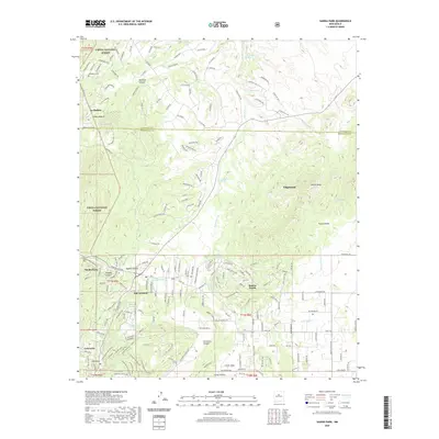
2020 Map of Sandia Park
USGS Topo · Published 2020About this map
Cibola National Forest defines the western landscape of this Bernalillo County study, where residential clusters like Sandia Park and San Antonito are situated at the threshold of the high wilderness. The map reveals a community-centric layout of schools and local gathering points, while the historic La Madera Cem reflects the deep-rooted local heritage. Drainage systems such as San Pedro Creek and the Arroyo San Antonio dictate the local geography, carving through the canyon-rich terrain including Gutierrez Canyon and Tejano Canyon. A notable jurisdictional division appears along the northern edge, where the Sandoval Co Bernalillo Co line bisects the foothills. The development of newer communities like Sandia Knolls and Homes Valley is clearly visible against the backdrop of more established settlements like Cañoncito, showing the residential expansion into the East Mountains area.
Find a feature on this map
172 named features on this map. Tap any name to fly to it.
Don’t see what you’re looking for? This feature index may not catch every label — zoom into the map to look around manually.
Map Details
Editions of this 2020 Sandia Park Map
This is the sole edition of this map. No revisions or reprints were ever made.
Other maps of this area

1892 · San Pedro
USGS Topo · 1:125,000

1954 · Sandia Crest
USGS Topo · 1:24,000

1954 · Placitas
USGS Topo · 1:24,000

1954 · Sandia Park
USGS Topo · 1:24,000

1954 · San Pedro
USGS Topo · 1:24,000
1954 · Tijeras
USGS Topo · 1:24,000

1954 · Sedillo
USGS Topo · 1:24,000

1954 · Hagan
USGS Topo · 1:24,000

1954 · Edgewood
USGS Topo · 1:24,000

1954 · San Felipe Pueblo
USGS Topo · 1:62,500