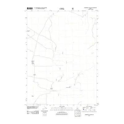
2011 Map of Sandrock Canyon
USGS Topo · Published 2011About this map
Sandrock Canyon and its complex system of drainages define this portion of Cassia County, Idaho, during the early 21st century. The map reveals a landscape managed for water access and movement, evidenced by the strategic naming of vital water sources such as Boosinger Spring, Mortenson Spring, and Point Spring. These features, alongside the network of forest roads including Keisaw Canyon Rd and Windmill Rd, suggest a region primarily used for ranching and resource management. The convergence of Eightmile Canyon and Little Eightmile Canyon provides a clear view of the local drainage patterns and topography. Notable landmarks such as Monument Canyon and Fisher Canyon anchor the geographic profile of this high-desert environment, offering essential data for those studying local land-use history and hydrological development in southern Idaho.
Find a feature on this map
18 named features on this map. Tap any name to fly to it.
Don’t see what you’re looking for? This feature index may not catch every label — zoom into the map to look around manually.
Map Details
Editions of this 2011 Sandrock Canyon Map
This is the sole edition of this map. No revisions or reprints were ever made.
Other maps of this area

1954 · Pocatello
USGS Topo · 1:250,000

1958 · Pocatello
USGS Topo · 1:250,000

1958 · Sublett
USGS Topo · 1:62,500

1959 · Strevell
USGS Topo · 1:62,500

1968 · Malta
USGS Topo · 1:24,000

1968 · Naf
USGS Topo · 1:24,000

1968 · Bridge
USGS Topo · 1:24,000
1985 · Sandrock Canyon
USGS Topo · 1:24,000
1985 · Strevell
USGS Topo · 1:24,000
1985 · Sublett
USGS Topo · 1:24,000