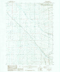
1985 Map of Sublett
USGS Topo · Published 1985About this map
Rift Valley dominates this Idaho landscape, where high-altitude watercourses like Warm Creek and Shirley Creek descend from the surrounding peaks toward the valley floor. The small settlement of Sublett serves as the primary human landmark in this part of Cassia County, positioned near where the drainage systems of Meadow Canyon and Big Canyon converge. This 1980s-era provisional survey illustrates the infrastructure of the period, including a prominent Pipeline cutting diagonally across the terrain and a localized Gravel Pit indicative of local resource use. The topography is defined by the contrast between the flat expanses of the rift and the steep, carved paths of Meadow Creek and Cold Spring Creek, providing a clear view of the hydrological and geological patterns of the region before modern digital mapping became standard.
Find a feature on this map
13 named features on this map. Tap any name to fly to it.
Don’t see what you’re looking for? This feature index may not catch every label — zoom into the map to look around manually.
Map Details
Editions of this 1985 Sublett Map
This is the sole edition of this map. No revisions or reprints were ever made.
Other maps of this area

1954 · Pocatello
USGS Topo · 1:250,000

1958 · Pocatello
USGS Topo · 1:250,000

1958 · Sublett
USGS Topo · 1:62,500

1959 · Strevell
USGS Topo · 1:62,500

1968 · Malta NE
USGS Topo · 1:24,000

1968 · Malta
USGS Topo · 1:24,000

1968 · Bridge
USGS Topo · 1:24,000
1985 · North Heglar Canyon
USGS Topo · 1:24,000
1985 · Sandrock Canyon
USGS Topo · 1:24,000
1985 · Sweetzer Canyon
USGS Topo · 1:24,000