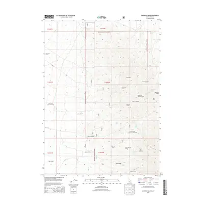
2013 Map of Sandrock Canyon
USGS Topo · Published 2013About this map
The Sawtooth National Forest dominates this section of the Black Pine Mountains in southern Idaho, where a complex network of drainages and seasonal water sources defines the landscape. Major geological features such as Sandrock Canyon and its North Fork cut through the high terrain, joined by others like Hutchey Canyon and Fisher Canyon. The distribution of named water sources, including Cottonwood Spring, Boosinger Spring, and Point Spring, indicates the critical points of hydration for livestock and wildlife in this arid environment. Transportation across the mountain range is limited to designated forest roads and canyon-floor routes like Keisaw Canyon Rd and 8 Mile Rd, reflecting the remote and difficult nature of the topography during the early 21st century.
Find a feature on this map
36 named features on this map. Tap any name to fly to it.
Don’t see what you’re looking for? This feature index may not catch every label — zoom into the map to look around manually.
Map Details
Editions of this 2013 Sandrock Canyon Map
This is the sole edition of this map. No revisions or reprints were ever made.
Other maps of this area

1954 · Pocatello
USGS Topo · 1:250,000

1958 · Pocatello
USGS Topo · 1:250,000

1958 · Sublett
USGS Topo · 1:62,500

1959 · Strevell
USGS Topo · 1:62,500

1968 · Malta
USGS Topo · 1:24,000

1968 · Naf
USGS Topo · 1:24,000

1968 · Bridge
USGS Topo · 1:24,000
1985 · Sandrock Canyon
USGS Topo · 1:24,000
1985 · Strevell
USGS Topo · 1:24,000
1985 · Sublett
USGS Topo · 1:24,000