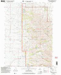
2001 Map of Sandrock Canyon
USGS Topo · Published 2006About this map
The Sawtooth National Forest dominates this section of southern Idaho, where the high-altitude terrain of the Black Pine Mountains is defined by a dense network of canyons and vital water sources. This 2001 revision, based on surveys from the early 1980s, highlights the essential role of springs in a dry mountain environment. Named sources like Hutchey Spring, Morrison Spring, and Cottonwood Spring are tucked away in deep drainages, including Dry Canyon and Eightmile Canyon. The topography reveals a landscape shaped by seasonal runoff, with prominent features such as Monument Canyon and Sandrock Canyon carving through the mountain range. For those researching land use in Cassia County, the map provides precise locations for remote water points such as Point Spring and Sixmile Spring, which served as critical landmarks for both forest management and local history.
Find a feature on this map
20 named features on this map. Tap any name to fly to it.
Don’t see what you’re looking for? This feature index may not catch every label — zoom into the map to look around manually.
Map Details
Editions of this 2001 Sandrock Canyon Map
This is the sole edition of this map. No revisions or reprints were ever made.
Other maps of this area

1954 · Pocatello
USGS Topo · 1:250,000

1958 · Pocatello
USGS Topo · 1:250,000

1958 · Sublett
USGS Topo · 1:62,500

1959 · Strevell
USGS Topo · 1:62,500

1968 · Malta
USGS Topo · 1:24,000

1968 · Naf
USGS Topo · 1:24,000

1968 · Bridge
USGS Topo · 1:24,000
1985 · Sandrock Canyon
USGS Topo · 1:24,000
1985 · Strevell
USGS Topo · 1:24,000
1985 · Sublett
USGS Topo · 1:24,000