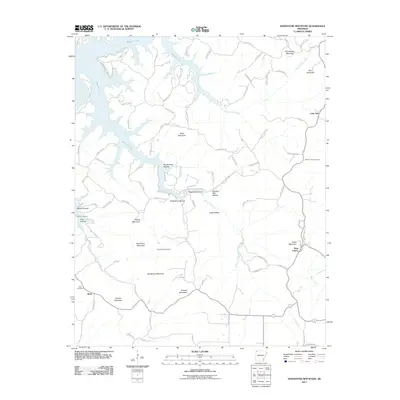
2011 Map of Sandstone Mountain
USGS Topo · Published 2011About this map
Beaver Lake defines the northwestern landscape of this Carroll County region, its flooded fingers reaching into deep drainages like Penitentiary Hollow and Hogscald Hollow. The terrain is characterized by high ridges and family-named peaks, including Sandstone Mountain and Polecat Mountain, which separate the various creek valleys. Small settlements and rural crossroads such as West Liberty and Lone Star serve as anchors for the local community, while the presence of Beulah Union Cemetery and Pemberton Cemetery offers significant value for those tracing local lineages. The network of county roads follows the natural contours of the land, connecting the high points of Grindstone Mountain down through timbered gaps like Durham Mill Hollow. This modern survey illustrates how traditional Ozark land patterns persist alongside the significant hydrological change brought by the lake.
Find a feature on this map
96 named features on this map. Tap any name to fly to it.
Don’t see what you’re looking for? This feature index may not catch every label — zoom into the map to look around manually.
Map Details
Editions of this 2011 Sandstone Mountain Map
This is the sole edition of this map. No revisions or reprints were ever made.
Other maps of this area

1900 · Eureka Springs
USGS Topo · 1:125,000

1901 · Eureka Springs
USGS Topo · 1:125,000

1945 · Harrison
USGS Topo · 1:250,000

1949 · Harrison
USGS Topo · 1:250,000

1954 · Harrison
USGS Topo · 1:250,000

1957 · Mundell
USGS Topo · 1:24,000

1957 · War Eagle
USGS Topo · 1:24,000
1957 · Beaver
USGS Topo · 1:24,000
1958 · Spring Valley
USGS Topo · 1:24,000

1958 · Hindsville
USGS Topo · 1:24,000