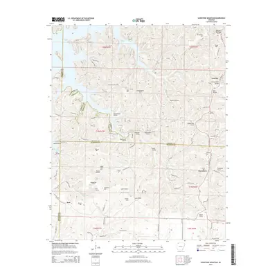
2014 Map of Sandstone Mountain
USGS Topo · Published 2014About this map
Beaver Lake defines the northwestern corner of this territory, where the fingers of the reservoir reach into a complex network of ridges and hollows at the intersection of Benton, Carroll, and Madison counties. The land is marked by high elevations such as Sandstone Mtn, Swain Mtn, and Grindstone Mtn, which overlook numerous drainage basins like Hogscald Hollow and Durham Mill Hollow. Small-scale aviation and local transit are evident at the Buck Mountain Airport, situated on a relatively flat ridge between Penitentiary Hollow and the lake.
Find a feature on this map
159 named features on this map. Tap any name to fly to it.
Don’t see what you’re looking for? This feature index may not catch every label — zoom into the map to look around manually.
Map Details
Editions of this 2014 Sandstone Mountain Map
This is the sole edition of this map. No revisions or reprints were ever made.
Other maps of this area

1900 · Eureka Springs
USGS Topo · 1:125,000

1901 · Eureka Springs
USGS Topo · 1:125,000

1945 · Harrison
USGS Topo · 1:250,000

1949 · Harrison
USGS Topo · 1:250,000

1954 · Harrison
USGS Topo · 1:250,000

1957 · Mundell
USGS Topo · 1:24,000

1957 · War Eagle
USGS Topo · 1:24,000
1957 · Beaver
USGS Topo · 1:24,000
1958 · Spring Valley
USGS Topo · 1:24,000

1958 · Hindsville
USGS Topo · 1:24,000