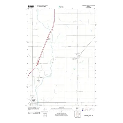
2010 Map of Sandstone North
USGS Topo · Published 2010About this map
Sandstone and Askov anchor this Pine County landscape, where the Kettle River carves a path through the terrain on its way toward the St. Croix. The map reveals a transition from the structured street grids of the small towns to the natural features that define the region's geography, most notably the Big Sink Hole and the dramatic Wolf Creek Falls. This 2010 survey highlights the local community centers, such as the Bethlehem Lutheran Church and its accompanying Bethlehem Lutheran Church Cemetery, which serve as vital touchpoints for genealogical research. Transportation corridors like Jernbanegate in Askov hint at the area's development around the rail line, while the Banning Campground and the Kettle River North Bound Rest Area indicate the importance of the river corridor for modern recreation and regional travel.
Find a feature on this map
40 named features on this map. Tap any name to fly to it.
Don’t see what you’re looking for? This feature index may not catch every label — zoom into the map to look around manually.
Map Details
Editions of this 2010 Sandstone North Map
This is the sole edition of this map. No revisions or reprints were ever made.
Other maps of this area

1953 · Duluth
USGS Topo · 1:250,000

1958 · Duluth
USGS Topo · 1:250,000

1961 · Sandstone
USGS Topo · 1:62,500

1961 · Moose Lake
USGS Topo · 1:62,500

1962 · Bruno
USGS Topo · 1:62,500

1962 · Cloverdale
USGS Topo · 1:62,500

1980 · Sandstone
USGS Topo · 1:100,000
1981 · Cloverdale
USGS Topo · 1:24,000
1981 · Askov Lookout Tower
USGS Topo · 1:24,000

1981 · Willow River
USGS Topo · 1:24,000