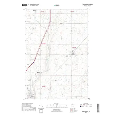
2019 Map of Sandstone North
USGS Topo · Published 2019About this map
The Kettle River carves a dramatic path through the center of this Pine County landscape, defining the character of the region with its complex hydrology and rocky riverbed. Near the site of Banning, the river descends through Hell's Gate Rapids, a sharp contrast to the more deliberate waters seen at Wolf Creek Falls and Quarry Rapids further south near Sandstone. This corridor served as a primary artery for early settlement and industry in the late nineteenth century, particularly for the quarrying operations that gave the southern town its name.
Find a feature on this map
63 named features on this map. Tap any name to fly to it.
Don’t see what you’re looking for? This feature index may not catch every label — zoom into the map to look around manually.
Map Details
Editions of this 2019 Sandstone North Map
This is the sole edition of this map. No revisions or reprints were ever made.
Other maps of this area

1953 · Duluth
USGS Topo · 1:250,000

1958 · Duluth
USGS Topo · 1:250,000

1961 · Sandstone
USGS Topo · 1:62,500

1961 · Moose Lake
USGS Topo · 1:62,500

1962 · Bruno
USGS Topo · 1:62,500

1962 · Cloverdale
USGS Topo · 1:62,500

1980 · Sandstone
USGS Topo · 1:100,000
1981 · Cloverdale
USGS Topo · 1:24,000
1981 · Askov Lookout Tower
USGS Topo · 1:24,000

1981 · Willow River
USGS Topo · 1:24,000