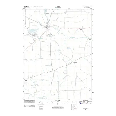
2010 Map of Sandy Lake
USGS Topo · Published 2010About this map
Sandy Lake and Stoneboro anchor this rural Mercer County landscape, where the waters of Sandy Creek and the expansive Lake Wilhelm define the local topography. This 2010 survey illustrates a region shaped by both recreation and early industry, featuring the Lake Wilhelm Dam and the site of Reeds Furnace to the east. The map is a significant resource for genealogists, as it identifies numerous burial grounds including Rocky Springs Cemetery, Yankee Hill Cemetery, and Oak Hill Cemetery. Small named crossroads and settlements like Hendersonville, Perrine Corners, and Bowie are linked by a network of country roads such as Glenn School Rd and Lytle School Rd, which reflect the community's educational history. The presence of the Wesleyan Campground and Fiddlers Green highlights the area's long-standing social and communal gathering spaces.
Find a feature on this map
81 named features on this map. Tap any name to fly to it.
Don’t see what you’re looking for? This feature index may not catch every label — zoom into the map to look around manually.
Map Details
Editions of this 2010 Sandy Lake Map
This is the sole edition of this map. No revisions or reprints were ever made.
Other maps of this area

1909 · Franklin
USGS Topo · 1:62,500

1910 · Hilliards
USGS Topo · 1:62,500

1911 · Franklin
USGS Topo · 1:62,500

1911 · Stoneboro
USGS Topo · 1:62,500

1912 · Hilliards
USGS Topo · 1:62,500

1913 · Stoneboro
USGS Topo · 1:62,500

1913 · Mercer
USGS Topo · 1:62,500

1939 · Mercer
USGS Topo · 1:62,500

1943 · Mercer
USGS Topo · 1:62,500

1943 · Stoneboro
USGS Topo · 1:62,500
Featured Places
- Sandy Lake, PA
- New Vernon Township, PA
- Jackson Township, PA
- Frenchcreek Township, PA
- Mineral Township, PA