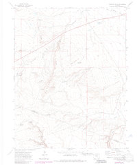
1970 Map of Sanford Hills
USGS Topo · Published 1985About this map
Sanford Hills and the rugged drainage of the Apishapa River characterize this landscape on the boundary of Pueblo and Las Animas Counties. The 1970 field check reveals a cattle-ranching economy reliant on scattered water sources, from the Lily Pond Spring to man-made developments like Rock Dam Reservoir and the Garr Windmill. Remote outposts such as English Camp and Jacobs Ranch underscore the isolation of the High Plains terrain during the late 20th century.
Find a feature on this map
30 named features on this map. Tap any name to fly to it.
Don’t see what you’re looking for? This feature index may not catch every label — zoom into the map to look around manually.
Map Details
Editions of this 1970 Sanford Hills Map
4 editions found
Other maps of this area

1891 · Apishapa
USGS Topo · 1:125,000

1893 · Apishapa
USGS Topo · 1:125,000

1897 · Apishapa
USGS Topo · 1:125,000

1954 · Trinidad
USGS Topo · 1:250,000

1955 · Trinidad
USGS Topo · 1:250,000

1958 · Trinidad
USGS Topo · 1:250,000

1959 · Trinidad
USGS Topo · 1:250,000
1970 · Red Top Ranch
USGS Topo · 1:24,000
1970 · Apishapa Bridge
USGS Topo · 1:24,000
1970 · Snowden Lake
USGS Topo · 1:24,000