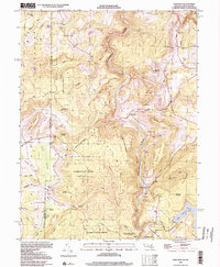
1999 Map of Sang Run
USGS Topo · Published 2000About this map
Negro Mountain and the deep gorge of the Youghiogheny River dominate this western Maryland landscape, where the border with West Virginia cuts through the high timberlands of Garrett State Forest. The rural character of the region is anchored by scattered mountain churches like White Rock Ch and Pine Grove Ch, alongside small schoolhouses including Lym Dale Sch and Elder Sch. Industrial and natural landmarks are tucked into the steep terrain, from the Sawmill and Power Plant near the river to the subterranean Friends Salt Peter Cave on Gap Hill. The area south of the river reflects the transition to recreation and conservation, featuring the edges of Deep Creek Lake and the preserved woodlands of Swallow Falls State Park. This terrain remains defined by its family-named peaks, such as Whites Knob, Bishop Hill, and Lewis Knob, which rise above the complex network of mountain runs and swamps.
Find a feature on this map
68 named features on this map. Tap any name to fly to it.
Don’t see what you’re looking for? This feature index may not catch every label — zoom into the map to look around manually.
Map Details
Editions of this 1999 Sang Run Map
2 editions found
Other maps of this area

1886 · St. George
USGS Topo · 1:125,000

1891 · St. George
USGS Topo · 1:125,000

1895 · Piedmont
USGS Topo · 1:125,000

1899 · Oakland
USGS Topo · 1:62,500

1900 · Accident
USGS Topo · 1:62,500

1900 · Oakland
USGS Topo · 1:62,500

1904 · Bruceton
USGS Topo · 1:62,500

1907 · Kingwood
USGS Topo · 1:62,500

1925 · Kingwood
USGS Topo · 1:62,500

1926 · Bruceton
USGS Topo · 1:62,500