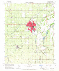
1965 Map of Sanger
USGS Topo · Published 1967About this map
The Kings River corridor defines the eastern edge of this mid-century landscape, where a sophisticated network of irrigation works including the Kingsburg Branch and Lonetree Canal supports the regional orchard and vineyard economy. The city of Sanger serves as the central hub, showing its dense grid of landmark buildings, including the Po, City Hall, and the Jackson Sch, just west of where the river braids into Hanke Slough and Cameron Slough.
Find a feature on this map
63 named features on this map. Tap any name to fly to it.
Don’t see what you’re looking for? This feature index may not catch every label — zoom into the map to look around manually.
Map Details
Editions of this 1965 Sanger Map
2 editions found
Other maps of this area

1920 · Orangedale School
USGS Topo · 1:24,000

1922 · Round Mountain
USGS Topo · 1:31,680

1922 · Trimmer
USGS Topo · 1:96,000

1923 · Malaga
USGS Topo · 1:31,680

1923 · Orangedale School
USGS Topo · 1:31,680

1923 · Clovis
USGS Topo · 1:31,680

1923 · Wahtoke
USGS Topo · 1:31,680

1923 · Sanger
USGS Topo · 1:31,680

1924 · Reedley
USGS Topo · 1:31,680

1924 · Selma
USGS Topo · 1:31,680