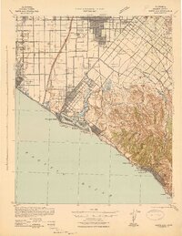
1942 Map of Santa Ana
USGS Topo · Published 1942About this map
The Santa Ana region during the early 1940s reveals an intricate coastal and agricultural landscape before the massive suburban expansion of later decades. The Santa Ana River cuts through a grid of developing towns and specialized agricultural districts, where small settlements like Greenville, Sugar, and Delhi are interspersed with active rail lines. The Southern Pacific and Atchison Topeka and Santa Fe railroads provide the backbone for local commerce, connecting the inland citrus and bean fields to the coast. Along the shoreline, Newport Beach, Balboa, and Huntington Beach appear as distinct coastal hubs, while the elevations of the San Joaquin Hills rise sharply to the southeast. Unique features like the Twenty Ranch Gun Club and Airway 39 highlight the era's land use, from private sporting grounds to early aviation infrastructure.
Find a feature on this map
82 named features on this map. Tap any name to fly to it.
Don’t see what you’re looking for? This feature index may not catch every label — zoom into the map to look around manually.
Map Details
Editions of this 1942 Santa Ana Map
2 editions found
Other maps of this area

1896 · Santa Ana
USGS Topo · 1:62,500

1896 · Anaheim
USGS Topo · 1:62,500

1896 · Las Bolsas
USGS Topo · 1:62,500

1896 · Downey
USGS Topo · 1:62,500

1898 · Anaheim
USGS Topo · 1:62,500

1899 · Downey
USGS Topo · 1:62,500

1901 · Southern California Sheet No. 1
USGS Topo · 1:250,000

1901 · Santa Ana
USGS Topo · 1:62,500

1901 · Anaheim
USGS Topo · 1:62,500

1902 · Capistrano
USGS Topo · 1:125,000