
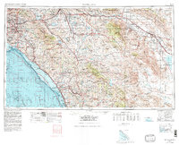
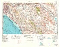
1959 Map of Santa Ana
USGS Topo · Published 1971About this map
Santa Ana and the burgeoning Southland suburbs appear during a period of rapid mid-century expansion, transitioning from the dense coastal developments of Orange and Costa Mesa to the high peaks of the Santa Ana Mountains. The landscape is defined by massive federal and state holdings, including the sprawling grounds of Camp Pendleton and the Cleveland National Forest. Further inland, the map captures the stark environmental contrast of the Anza-Borrego Desert State Park and the low-lying Salton Sea.
Find a feature on this map
140 named features on this map. Tap any name to fly to it.
Don’t see what you’re looking for? This feature index may not catch every label — zoom into the map to look around manually.
Map Details
Editions of this 1959 Santa Ana Map
3 editions found
Other maps of this area

1893 · El Cajon
USGS Topo · 1:62,500

1893 · Oceanside
USGS Topo · 1:62,500

1893 · Escondido
USGS Topo · 1:62,500

1894 · Los Angeles
USGS Topo · 1:62,500

1894 · Pomona
USGS Topo · 1:62,500

1896 · Santa Ana
USGS Topo · 1:62,500

1896 · Pasadena
USGS Topo · 1:62,500

1896 · Anaheim
USGS Topo · 1:62,500

1896 · San Bernardino
USGS Topo · 1:62,500

1896 · Las Bolsas
USGS Topo · 1:62,500