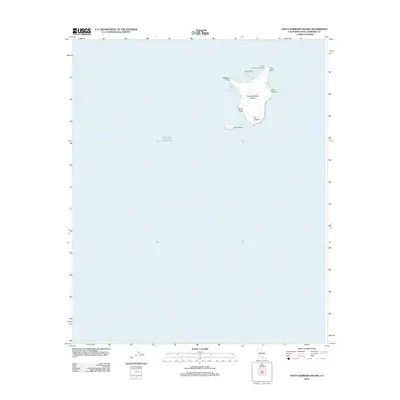
2012 Map of Santa Barbara Island
USGS Topo · Published 2012About this map
Santa Barbara Island stands as a solitary landmass surrounded by the Pacific Ocean in this coastal survey. The island's geography is defined by its dramatic verticality, rising to its highest elevation at Signal Peak. The surrounding waters and rugged shoreline are detailed with numerous nautical and topographic landmarks, including Webster Point on the western edge and Arch Point to the northeast. To the southeast, the smaller Sutil Island sits offshore, while inland erosional features such as Cave Canyon and Cat Canyon cut through the island’s interior.
Find a feature on this map
12 named features on this map. Tap any name to fly to it.
Don’t see what you’re looking for? This feature index may not catch every label — zoom into the map to look around manually.
Map Details
Editions of this 2012 Santa Barbara Island Map
This is the sole edition of this map. No revisions or reprints were ever made.
Other maps of this area

1949 · Long Beach
USGS Topo · 1:250,000

1957 · Long Beach
USGS Topo · 1:250,000

1958 · Long Beach
USGS Topo · 1:250,000

1960 · Long Beach
USGS Topo · 1:250,000
1981 · Santa Catalina Island
USGS Topo · 1:100,000
1981 · Long Beach
USGS Topo · 1:100,000
1984 · Laguna Harbor
USGS Topo · 1:100,000
1993 · San Nicolas Island
USGS Topo · 1:100,000
2012 · Santa Barbara Island OE N
USGS Topo · 1:24,000
2015 · Santa Barbara Island OE N
USGS Topo · 1:24,000