
1957 Map of Long Beach
USGS Topo · Published 1957About this map
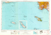
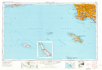
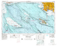
Santa Catalina Island and the neighboring San Clemente Island dominate the maritime portion of this mid-century survey, revealing a coastal landscape defined by naval installations and a rapidly densifying urban mainland. On the coast, military activity is anchored by the Ft MacArthur Upper Reservation and Ft MacArthur Lower Reservation near Terminal Island, while the interior shows the maturing street grids of South Gate, Huntington Park, and Santa Fe Springs.
Find a feature on this map
91 named features on this map. Tap any name to fly to it.
Don’t see what you’re looking for? This feature index may not catch every label — zoom into the map to look around manually.
Map Details
Editions of this 1957 Long Beach Map
4 editions found
Other maps of this area

1894 · Los Angeles
USGS Topo · 1:62,500

1894 · Pomona
USGS Topo · 1:62,500

1896 · Santa Ana
USGS Topo · 1:62,500

1896 · Pasadena
USGS Topo · 1:62,500

1896 · Anaheim
USGS Topo · 1:62,500

1896 · Redondo
USGS Topo · 1:62,500

1896 · Las Bolsas
USGS Topo · 1:62,500

1896 · Santa Monica
USGS Topo · 1:62,500

1896 · San Pedro
USGS Topo · 1:62,500

1896 · Downey
USGS Topo · 1:62,500