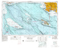
1957 Map of Long Beach
USGS Topo · Published 1979About this map
Santa Catalina Island and the rugged offshore chain dominate this 1957 bathymetric and topographic study, which captures the Southern California coast during a period of intense post-war urbanization. While the mainland shows the dense expansion of Long Beach, Torrance, and Compton, the maritime focus reveals the complex underwater topography of the Santa Monica Basin and the Santa Rosa-Cortes Ridge.
Find a feature on this map
99 named features on this map. Tap any name to fly to it.
Don’t see what you’re looking for? This feature index may not catch every label — zoom into the map to look around manually.
Map Details
Editions of this 1957 Long Beach Map
4 editions found

Other maps of this area

1894 · Los Angeles
USGS Topo · 1:62,500

1894 · Pomona
USGS Topo · 1:62,500

1896 · Santa Ana
USGS Topo · 1:62,500

1896 · Pasadena
USGS Topo · 1:62,500

1896 · Anaheim
USGS Topo · 1:62,500

1896 · Redondo
USGS Topo · 1:62,500

1896 · Las Bolsas
USGS Topo · 1:62,500

1896 · Santa Monica
USGS Topo · 1:62,500

1896 · San Pedro
USGS Topo · 1:62,500

1896 · Downey
USGS Topo · 1:62,500