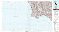
1981 Map of Long Beach
USGS Topo · Published 1981About this map
Palos Verdes Hills dominate the coastal topography of this 1981 survey, providing a physical anchor to the dense suburban expansion of the Los Angeles Basin. This period shows the mature development of industrial and transportation corridors, from the sprawling Los Angeles International Airport in the north to the complex maritime infrastructure of San Pedro Bay. The map captures the coastline as a series of managed spaces, featuring Dockweiler Beach State Park and the massive breakwaters protecting the Los Angeles Middle Harbor.
Find a feature on this map
114 named features on this map. Tap any name to fly to it.
Don’t see what you’re looking for? This feature index may not catch every label — zoom into the map to look around manually.
Map Details
Editions of this 1981 Long Beach Map
3 editions found
Other maps of this area

1894 · Los Angeles
USGS Topo · 1:62,500

1894 · Pomona
USGS Topo · 1:62,500

1896 · Santa Ana
USGS Topo · 1:62,500

1896 · Pasadena
USGS Topo · 1:62,500

1896 · Anaheim
USGS Topo · 1:62,500

1896 · Redondo
USGS Topo · 1:62,500

1896 · Las Bolsas
USGS Topo · 1:62,500

1896 · Santa Monica
USGS Topo · 1:62,500

1896 · San Pedro
USGS Topo · 1:62,500

1896 · Downey
USGS Topo · 1:62,500