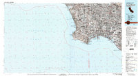
1981 Map of Long Beach
USGS Topo · Published 1981About this map
The Rancho Palos Verdes peninsula and the sprawling industrial corridor of Long Beach anchor this 1981 survey of the South Bay and Gateway Cities. The map illustrates a highly developed landscape where major infrastructure like Los Angeles International Airport and the Harbor Fwy serve a network of residential and commercial centers including Inglewood, Torrance, and Compton. The coastal geography is particularly well-defined, tracing the shoreline from Marina Del Rey down to Seal Beach.
Find a feature on this map
100 named features on this map. Tap any name to fly to it.
Don’t see what you’re looking for? This feature index may not catch every label — zoom into the map to look around manually.
Map Details
Editions of this 1981 Long Beach Map
3 editions found
Other maps of this area

1894 · Los Angeles
USGS Topo · 1:62,500

1894 · Pomona
USGS Topo · 1:62,500

1896 · Santa Ana
USGS Topo · 1:62,500

1896 · Pasadena
USGS Topo · 1:62,500

1896 · Anaheim
USGS Topo · 1:62,500

1896 · Redondo
USGS Topo · 1:62,500

1896 · Las Bolsas
USGS Topo · 1:62,500

1896 · Santa Monica
USGS Topo · 1:62,500

1896 · San Pedro
USGS Topo · 1:62,500

1896 · Downey
USGS Topo · 1:62,500